-
Administrator

It's starting to get interesting.
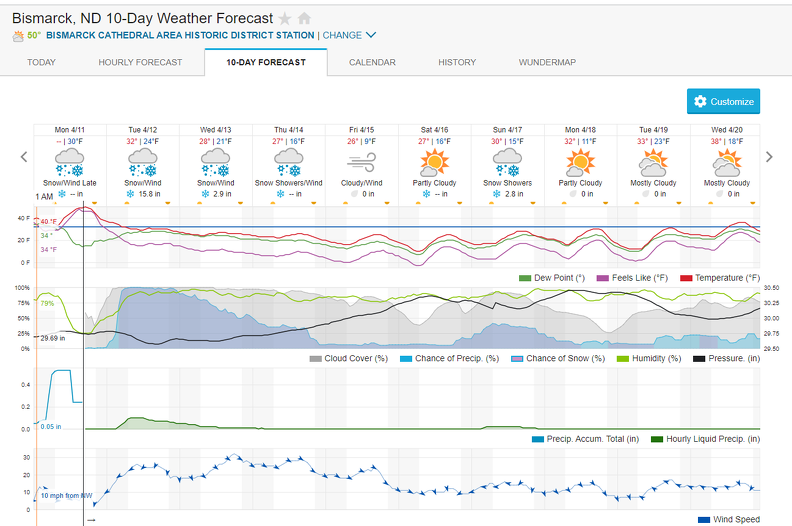
BLIZZARD WARNING
ISSUED: 2:28 PM APR. 11, 2022 – NATIONAL WEATHER SERVICE
...BLIZZARD WARNING REMAINS IN EFFECT FROM 7 AM CDT /6 AM MDT/
TUESDAY TO 7 PM CDT /6 PM MDT/ THURSDAY...
* WHAT...Heavy snow and blizzard conditions expected. Total snow
accumulations between 12 and 24 inches, with locally higher
amounts up to 30 inches possible. Winds gusting as high as 50 mph.
* WHERE...Southwest and portions of central North Dakota.
* WHEN...From 7 AM CDT /6 AM MDT/ Tuesday to 7 PM CDT /6 PM MDT/
Thursday.
* IMPACTS...Travel will become very difficult to impossible.
Widespread blowing snow could significantly reduce visibility.
PRECAUTIONARY/PREPAREDNESS ACTIONS...
Travel should be restricted to emergencies only. If you must travel,
have a winter survival kit with you. Notify a friend or family
member of your travel plans. If you get stranded, stay with your
vehicle. The latest road conditions can be obtained by calling 5 1 1.
 Posting Permissions
- You may not post new threads
- You may not post replies
- You may not post attachments
- You may not edit your posts
-
Forum Rules


 Reply With Quote